


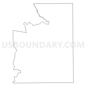
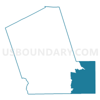
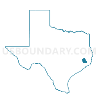
Voting District 0004, Liberty County, Texas
About
Outline
Summary
| Unique Area Identifier | 675448 |
| Name | Voting District 0004 |
| County | Liberty County |
| State | Texas |
| Area (square miles) | 152.20 |
| Land Area (square miles) | 151.38 |
| Water Area (square miles) | 0.82 |
| % of Land Area | 99.46 |
| % of Water Area | 0.54 |
| Latitude of the Internal Point | 29.98391910 |
| Longtitude of the Internal Point | -94.52736360 |
Maps

Graphs
Select a template below for downloading or customizing gragh for Voting District 0004, Liberty County, Texas


Neighbors
Neighoring Voting District (by Name) Neighboring Voting District on the Map
- Voting District 0002, Chambers County, TX
- Voting District 0007, Chambers County, TX
- Voting District 0011, Liberty County, TX
- Voting District 0013, Liberty County, TX
- Voting District 0015, Hardin County, TX
- Voting District 0024, Jefferson County, TX
- Voting District 0091, Jefferson County, TX
Top 10 Neighboring County Subdivision (by Population) Neighboring County Subdivision on the Map
- Liberty-Dayton CCD, Liberty County, TX (41,322)
- Nome-China CCD, Jefferson County, TX (10,201)
- Anahuac CCD, Chambers County, TX (6,777)
- Winnie-Stowell CCD, Chambers County, TX (6,274)
- Sour Lake CCD, Hardin County, TX (5,609)
- Daisetta CCD, Liberty County, TX (3,492)
Top 10 Neighboring Place (by Population) Neighboring Place on the Map
Top 10 Neighboring Unified School District (by Population) Neighboring Unified School District on the Map
- Liberty Independent School District, TX (11,256)
- Hardin-Jefferson Independent School District, TX (10,790)
- Anahuac Independent School District, TX (6,780)
- East Chambers Independent School District, TX (6,277)
- West Hardin County Consolidated Independent School District, TX (3,643)
- Hull-Daisetta Independent School District, TX (3,079)
- Devers Independent School District, TX (941)
Top 10 Neighboring State Legislative District Lower Chamber (by Population) Neighboring State Legislative District Lower Chamber on the Map
- State House District 18, TX (150,998)
- State House District 23, TX (144,933)
- State House District 19, TX (139,948)
- State House District 21, TX (137,058)
Top 10 Neighboring State Legislative District Upper Chamber (by Population) Neighboring State Legislative District Upper Chamber on the Map
Top 10 Neighboring 111th Congressional District (by Population) Neighboring 111th Congressional District on the Map
- Congressional District 8, TX (833,770)
- Congressional District 2, TX (782,375)
- Congressional District 14, TX (779,704)
Top 10 Neighboring Census Tract (by Population) Neighboring Census Tract on the Map
- Census Tract 7014, Liberty County, TX (7,112)
- Census Tract 7104.01, Chambers County, TX (6,274)
- Census Tract 302, Hardin County, TX (5,609)
- Census Tract 7013, Liberty County, TX (3,492)
- Census Tract 7103, Chambers County, TX (2,890)
- Census Tract 115, Jefferson County, TX (2,330)
Top 10 Neighboring 5-Digit ZIP Code Tabulation Area (by Population) Neighboring 5-Digit ZIP Code Tabulation Area on the Map
- 77575, TX (15,949)
- 77665, TX (6,446)
- 77659, TX (4,910)
- 77533, TX (1,022)
- 77560, TX (1,005)
- 77538, TX (934)
- 77629, TX (877)